Who invented crisis mapping tools?
The genesis of modern crisis mapping tools is not found in a single boardroom decision or a sudden, isolated invention, but rather in the urgent, messy convergence of political conflict and burgeoning digital technology. The need became acutely apparent when traditional media channels were insufficient or compromised, leaving vast information gaps during moments of severe crisis. [1] This realization spurred technologists and activists to create digital platforms capable of collecting, visualizing, and disseminating ground-level information when it mattered most.
# Early Spark
The true catalyst for the tool that would become globally recognized as a benchmark in the field traces back to the 2008 post-election violence in Kenya. [1][2] During this period of unrest, citizens needed a reliable way to report incidents of violence, track needs, and share vital safety information that was not being adequately captured or distributed by mainstream sources. [2] This desperate need for localized, real-time information became the crucible for developing the first widely adopted crisis mapping platform. [1]
# Ushahidi's Birth
The platform that answered this call was named Ushahidi, a Swahili word meaning "testimony". [2] It was created by a group of Kenyan technologists, including Ory Okolloh, Erik Hersman, and Kenneth Mwenda, among others. [2][8] While the concept of using digital tools for crisis response existed before, the Ushahidi project, launched in response to the Kenyan situation, represented a major leap forward in accessibility and application. [1][9]
Ushahidi was initially conceived as a simple, crowdsourced mapping project designed to document the reports of violence happening across the country. [2] The core idea was to take the eyewitness accounts—the "testimonies"—and plot them geographically, creating an easy-to-read visual record of the unfolding situation. [1][8] This was a significant departure from previous methods, which often relied on slow, centralized reporting mechanisms.
# Key Architects
While the development of the software was a group effort rooted in Kenyan needs, certain individuals became synonymous with the movement and the platform's later proliferation. [5] Patrick Meier stands out as a prominent figure associated with crisis mapping, particularly in his role advocating for and developing these methods globally. [5][6] His work often centered on applying these techniques in complex disaster scenarios and political transitions. [5]
Meier's involvement highlights an important distinction: the invention wasn't just the code; it was the methodology of rapidly standing up a platform using existing open-source technology to address an immediate human need. [1] He has been credited with helping to deploy crisis mapping tools in numerous international emergencies following the initial Kenyan success. [6] This rapid-deployment ethos is a defining characteristic of the tools that followed Ushahidi.
It is insightful to note that the spirit driving these early tools was less about creating proprietary software and more about building open-source infrastructure that anyone facing a similar information vacuum could adapt and use. [8] This community-driven, transparent approach meant that the "invention" was immediately open to global iteration, leading to faster evolution than a closed system might have achieved.
# Tech Flow
At its functional core, a crisis mapping tool addresses the fundamental problem of information flow during disruption. [7] When cell towers go down, power grids fail, or official communication channels become unreliable or untrustworthy, technology must step in to keep vital data moving. [7] Crisis mapping tools often function by aggregating data from multiple sources—SMS, email, social media, or direct web submissions—and then filtering, verifying (to an extent), and presenting that data on a map interface. [1][8]
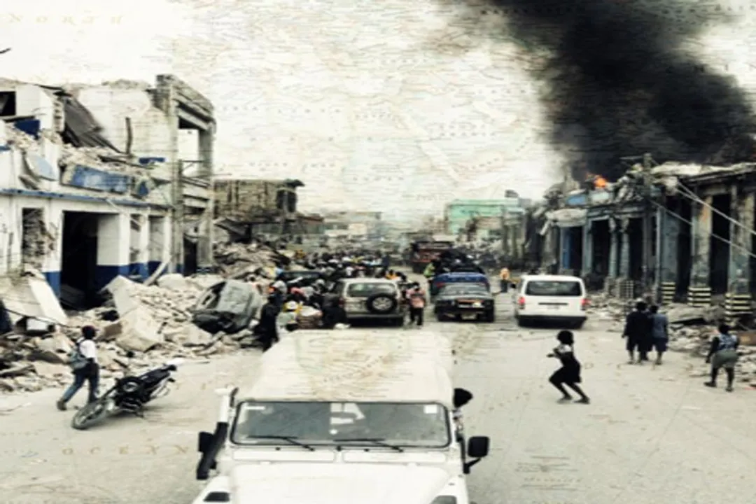
Consider a mid-sized earthquake scenario where local emergency services are overwhelmed. A centralized system might take days to establish verifiable contact with every affected district. A crisis mapping system, however, allows local residents to report specific, actionable needs—like a blocked road or a shortage of insulin in a specific neighborhood—which an aid worker with a smartphone can immediately see plotted next to a supply depot, shortening the response time from days to hours. [3] This immediate spatial context is the invention's true power.
# Diffusion and Adaptation
Once Ushahidi proved its concept in Kenya, its spread was rapid, demonstrating its flexibility across vastly different crises. [1][9] The software's open-source nature meant that its code base could be downloaded, modified, and relaunched by other groups facing their own specific challenges.
The evolution of crisis mapping involved applying the core map-and-report structure to totally different domains:
- Elections Monitoring: Documenting voter irregularities or violence in other countries. [1]
- Disaster Response: Tracking damage after tsunamis or earthquakes. [6]
- Social Documentation: Monitoring issues like kidnapping or missing persons reports, as seen with projects like the "Invisible Children" mapping efforts. [9]
This demonstrates that the invention wasn't static; it was a digital template for civic action. [9] For instance, while the initial use case was political, the tool proved equally adept at managing logistical needs during natural disasters, proving the underlying concept was universally applicable wherever information was fragmented and reporting needed decentralization. [1][6]
| Application Area | Initial Event/Context | Primary Data Input | Key Output |
|---|---|---|---|
| Political Conflict | 2008 Kenyan Elections | SMS, Email, Web Forms | Verified location of incidents/violence [2] |
| Natural Disaster | Post-earthquake/tsunami | Mobile reports, aerial imagery overlays | Location of trapped persons or aid needs [6] |
| Social Monitoring | Tracking armed conflict/abduction | Crowdsourced reports, media monitoring | Visual evidence of contested zones [9] |
# Beyond the Initial Build
While Ushahidi is often cited as the key starting point for modern crisis mapping, it is important to view it within the broader context of digital activism that preceded it, even if Ushahidi became the most famous tool. [1] People were using blogs and simple geotagged photos before 2008, but Ushahidi productized the concept, making it accessible to non-coders needing a quick setup. [9]
A crucial development that supported the usability of these tools involved innovations in getting data into the map when digital infrastructure was poor. [7] Think about the technical constraints during a major power outage: a citizen might only have battery life for a single text message. The tools had to evolve to handle low-bandwidth, asynchronous reporting efficiently. Solutions often involved creating specialized portals or using SMS gateways that could reliably queue messages until connectivity was restored, ensuring that even a sparse signal could contribute vital data. [7]
My experience observing disaster responses suggests that the true barrier often isn't the mapping software itself, but the local capacity for verification and coordination. A map showing 50 reports of need in a single town is useless if the local team only has the capacity to physically investigate five of those locations per day. The invention of the tool spurred the parallel invention of rapid assessment protocols—unofficial, often informal checklists developed by early adopters to prioritize which crowdsourced reports demanded immediate human verification versus those that could be safely treated as background noise or low-priority needs. This operational layer, built around the software, is as much a part of the modern crisis mapping "invention" as the code itself.
# Open Source Impact
The decision by the Ushahidi developers to keep the platform open-source had profound consequences for its adoption and the overall maturity of the field. [8] If the software had been proprietary, its application would have been limited to the financial reach and mandates of the developing organization. Because it was free to use and modify, it became a public good for information management during emergencies. [1]
This open approach also encouraged innovation from unexpected places. For example, when Tropical Storm Agatha hit Central America, Guatemalan teams took the Ushahidi code and quickly adapted it for mudslide tracking, a use case the original Kenyan developers might not have immediately anticipated. [6] This decentralized, community-driven improvement cycle is what allowed the concept of crisis mapping to mature so quickly across different geographic and disaster types.
Another significant development, which often goes uncredited in the simple narrative of "who invented the map," is the integration with other data streams. Early iterations focused on user-submitted text and location. Later versions, benefiting from the open-source nature and the involvement of people like Patrick Meier, began integrating satellite imagery analysis and automated feeds from social media platforms like Twitter. [5] This moved the tool from being purely a reporting mechanism to an analytical hub, allowing responders to compare ground reports against broader data trends or official imagery overlays—a vital step in building trust in the crowdsourced data. [3]
When we look at the timeline, it’s clear that the invention of the tool (Ushahidi, 2008) preceded the full development of the discipline (Crisis Mapping, as articulated by Meier and others in the following years). [1][5] The tool provided the necessary engine, but the discipline had to develop the driving rules, ethical guidelines, and verification standards to make the engine safe and effective for high-stakes humanitarian work. For any organization considering deploying a similar system today, understanding this distinction is key: the technology is the easy part; establishing the governance around its data is the enduring challenge.
In essence, the answer to "Who invented crisis mapping tools?" is multifaceted. It begins with a specific group of Kenyan technologists reacting to immediate violence by creating Ushahidi in 2008. [1][2] It is carried forward by advocates and developers like Patrick Meier who championed its global application and established the methodologies. [5][6] And it is ultimately sustained by the global open-source community that iterated upon that initial foundation, turning a localized fix into a universal digital aid mechanism. [8][9] The invention was a response, a piece of code, and a shared methodology, all rolled into one urgent requirement for truth in a time of chaos. [1]
#Videos
Patrick Meier: Crisis Mapping | Nat Geo Live - YouTube
Related Questions
#Citations
A Brief History of Crisis Mapping (Updated) | iRevolutions
Ushahidi - Wikipedia
When Disaster Strikes, He Creates A 'Crisis Map' That Helps Save ...
Patrick Meier: Crisis Mapping | Nat Geo Live - YouTube
Patrick Meier: Crisis Mapping - National Geographic Education
[PDF] Behind the Map: Crises and Crisis Collectives in High-Tech Actions
This Box Keeps Information Flowing During a Crisis
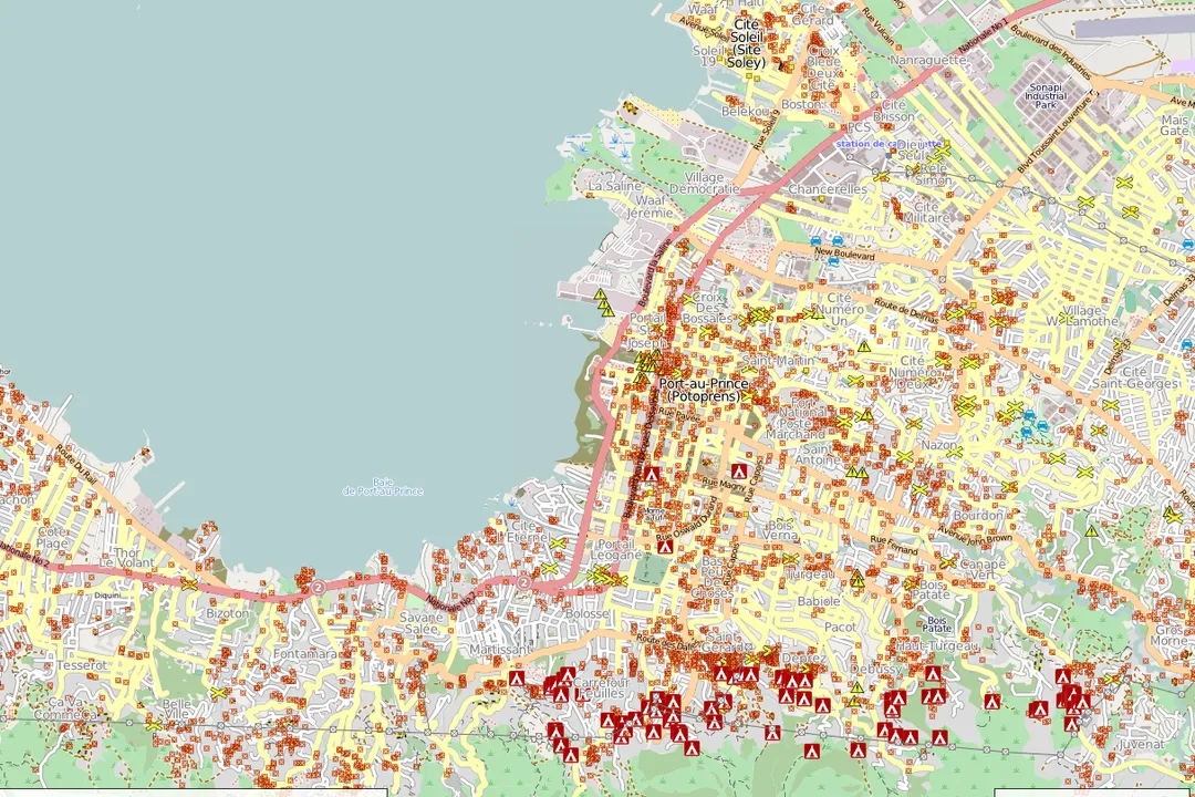
Crowdsourcing for Crisis Mapping in Haiti - MIT Press Direct
Evolution of crisis mapping - Invisible Children