Who invented urban planning tools?
The history of urban planning is often told through the grand visions of architects and the legislative achievements of civic leaders, but to truly understand who invented the tools of the trade, we must look closer at the diagrams, maps, regulations, and analytical models that gave form to those ideas. The "invention" wasn't a single moment, but a succession of influential visual and procedural distillations that captured and persuaded the public toward a new way of seeing and building the human settlement.
# Ancient Forms

The roots of planning tools stretch back millennia, long before the term "urban planner" existed. Archaeologists find evidence of planning in the third millennium BCE cities of the Indus Valley civilization, like Mohenjo-Daro and Harappa, which featured paved streets laid out in precise grid patterns. [1][5] This orthogonality—streets intersecting at right angles—was later formalized and popularized by the ancient Greek architect Hippodamus of Miletus (498–408 BC), who is often called the "father of European urban planning" for this very layout, known as the Hippodamian plan. [1] The grid, a simple, pragmatic tool, embodied order and allowed for rapid, scalable development, a characteristic later adopted by the Romans for their camps and cities for military and convenience purposes. [1]
This ancient reliance on the grid, emphasizing simplicity and orientation, persisted, yet the Renaissance brought a shift toward theoretical idealization. Inspired by classical rules, Renaissance designers imagined ideal cities utilizing complex geometry and symmetry in plan view, striving for utopian perfection divorced from existing geography. Later, the grand, sweeping gestures of figures like Baron Georges-Eugène Haussmann in Paris, with his creation of long, straight, wide boulevards, provided a different kind of organizational tool—one focused on modernization, flow, and political control—that physically rewired an existing metropolis. [1]
# Reactionary Inventions
The rapid, often chaotic growth of industrial cities in the 19th century spurred the next wave of planning inventions, largely as a reaction to perceived "evils" like overcrowding and poor sanitation. [1] This era introduced prescriptive tools intended to manage the scale and social fallout of industrial life.
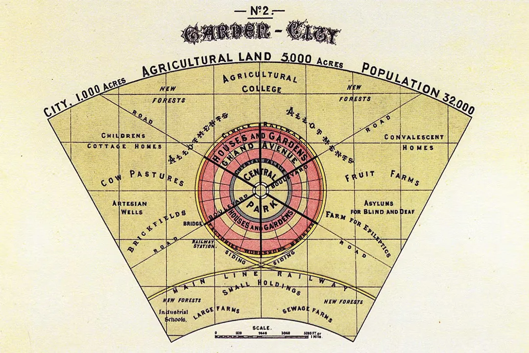
One of the most enduring conceptual tools came from Sir Ebenezer Howard, whose 1898 publication introduced the Garden City concept. [5] Howard’s invention wasn't just a policy; it was a powerful, circular diagram showing “A Group of Smokeless, Slumless Cities” linked by transit and surrounded by a greenbelt, effectively marketing a social and spatial reform package that aimed to capture the best of both town and country. [5] His visual tool had a profound, long-term impact on 20th-century orthodoxy regarding decentralization. [5]
Simultaneously, others invented tools focused on regulating the internal character of the city block. The American City Beautiful movement, promoted by theorists like Charles Mulford Robinson, author of the first city planning guide in 1901, was supported by visual tools meant to instill civic pride. [4] Meanwhile, landscape architects like Frederick Law Olmsted, Sr., invented the concept of integrated green infrastructure, designing entire systems of parks and parkways to connect urban populations with nature. [4]
The most fundamental regulatory tool of the 20th century arrived with the dawn of municipal zoning. The New York City 1916 Zoning Resolution was a landmark invention, and its architects developed key procedural and visual tools to express it. [4] Edward Murray Bassett was central to this effort, helping draft the code that separated land use into residential, commercial, and industrial zones (Euclidean zoning). [4] Critically, this resolution also regulated the building envelope through setbacks to ensure light and air reached the streets below. The illustrator Hugh Ferriss turned this regulatory requirement into an iconic aesthetic tool. His moody charcoal renderings—the setback diagram—didn't just explain the new law; they defined the look of the burgeoning skyscraper city, powerfully persuading the public of the law’s visual consequence.
If we consider the grid plan as the ultimate top-down tool, imposing rigid order, the work of Pierre Charles L’Enfant in Washington D.C. stands as an early, large-scale attempt to use a master diagram to reshape a landscape's natural topography—a conflict between imposed order and inherent geography that would challenge planners for centuries. [1] The layered mapping techniques later pioneered by Ian Lennox McHarg in Design with Nature directly addressed this tension, providing the foundation for modern GIS by analytically mapping ecological constraints onto the planned surface. [4] This evolution shows planning tools shifting from dictating what must be built (the setback diagram) to diagnosing what already is (McHarg’s layered ecology map).
# Mapping Experience and Process

As the 20th century progressed, critical failures in large-scale, expert-driven planning spurred the invention of diagnostic and participatory tools meant to capture the messy reality of urban life from the bottom up. [5]
One crucial conceptual tool was Patrick Geddes's "Valley Section" diagram from 1909, a transect that analyzed how human activities relate to geographical context across a landscape, emphasizing context sensitivity. This idea of looking at context found a modern expression in Kevin Lynch’s work. His "cognitive mapping" system, resulting in The Image of the City (1960), was an invented method of data collection—asking residents to map cities from memory—to reveal the city's "imageable" features. [4] This was a deliberate move away from purely physical planning toward understanding user experience.
This emphasis on lived experience was crystallized in procedure by Sherry Arnstein. Her 1969 article introduced the "Ladder of Citizen Participation," a procedural tool that organized public involvement into tiers, ranging from non-participation to genuine partnership. [4] Arnstein’s framework gave planners and activists a common language to argue for inclusivity, directly influencing the theoretical basis for advocacy planning. [4] It signals a major invention: the tool used to measure how the public is engaged, rather than just what is built.
In a more radical critique of top-down expertise, the Situationist International in Europe developed psychogeography, mapped through suggestive diagrams of drifts through Paris by Guy Debord. While not a regulatory tool, psychogeography was an experiential method designed to resist the "tyranny of modernism's urban form agenda" by asserting that the city is created moment-by-moment through individual experience. This spirit of bottom-up, ephemeral intervention finds its echo today in tactical urbanism movements. [5]
It is fascinating to compare the procedural tools that emerged in the 1920s for the neighborhood scale with those for the metropolitan scale. While Clarence Arthur Perry developed the prescriptive "neighborhood unit" concept, guiding the layout of local streets and separation of uses, Frederic Adrian Delano chaired the effort behind the Regional Plan of New York and Its Environs (1929)—the first comprehensive, long-range metropolitan plan in the US, which relied on extensive data-based analysis. [4] The evolution from Perry’s defined unit to Delano’s regional scope demonstrates how the scale of the problem dictated the type of tool invented.
# Modern Quantification and Optimization
The latter half of the 20th century and into the 21st has seen planning tools become increasingly quantitative, ecological, and focused on efficiency and impact assessment.
A major analytical tool that reshaped planning rationale was Michael Mann’s "hockey stick" graph. [5] Though primarily a climate science artifact, its dramatic visualization of rapid temperature spikes became a central organizing idea for planners, linking land-use efficiency (density, transit use) directly to climate mitigation goals. [5] This provided a data-driven justification for policies promoting compact growth.
Building on ecological principles, Ian Lennox McHarg essentially invented the analytical basis for GIS through his advocacy for ecological planning and his layered mapping techniques. [4] By creating maps that showed underlying ecological conditions (soil, slope, water), he allowed planners to overlay proposed developments against natural constraints, a vast improvement over earlier methods that simply ignored topography.
On the economic side, Donald Shoup invented a framework for understanding the often-ignored externalities of urban policy. His extensive study of parking, summarized in The High Cost of Free Parking, provided cities with a sophisticated analytical tool to re-evaluate the true community and environmental costs associated with free or subsidized vehicle storage, leading to policy adjustments nationwide. [4]
This focus on optimization is also seen in the way regulatory tools have matured. In contrast to the absolute separation enforced by modernist concepts like Le Corbusier’s Radiant City, which often resulted in isolated failures like Pruitt-Igoe, [5] modern tools seek finer adjustments. For instance, Ronald Shiffman pushed for New York City’s first inclusionary zoning policy as a tool to mandate social equity within the regulatory structure of private development. [4]
If we look at the sheer volume of influence, the foundational work by figures like Harland Bartholomew, whose Urban Land Uses (1932) championed quantitative analysis, established a measurable basis for planning that was far more defensible in a political arena than purely aesthetic arguments. [4] His quantification of land use provided a vital, if sometimes dry, toolset for justifying comprehensive plans. [4]

# The Ongoing Invention: Digital and Participatory
The most recent inventions in the urban planning toolkit are not static diagrams but dynamic, digital environments and complex engagement systems. Today, planners use Geographic Information Systems (GIS) to model current conditions and project future impacts, integrating demographic, geographic, and economic data into a single projection platform. [1]
The next generation of tools involves Urban Digital Twins (UDTs), which merge AI and the Internet of Things (IoT) to create real-time simulations of urban development scenarios, allowing for data-driven insight into traffic patterns and resource allocation before ground is even broken. [1] This represents the apotheosis of the rational-comprehensive approach, turning theory into live simulation.
However, the persistence of human-centered thinking, fueled by critics like Jane Jacobs and her emphasis on livable streets, ensures that purely technical tools remain contested. [1] The contemporary planning toolkit, therefore, must balance the hyper-detailed, predictive power of digital modeling with methods for capturing qualitative, on-the-ground experience. A planner today might use a digital twin to model traffic flow but must still consult Arnstein’s Ladder to ensure the process used to adjust that flow is equitable. The invention is increasingly about interface—how to make complex data and high-level policy accessible and meaningful to the average resident, moving beyond the static, god-like "plan view" that obscures the sensual qualities of place.
Ultimately, the question of who invented urban planning tools yields a diffuse answer. It was the ancient Greeks for the orthogonal grid, [1] the Renaissance for formal symmetry, Howard for the diagrammatic concept of the Garden City, [5] Bassett and his commission for the regulatory power of zoning, [4] Geddes for the analytical power of the transect, and McHarg for the layered ecological map. [4] Modern planners are not just users of these tools; they are constantly remixing, digitizing, and critiquing them, ensuring that the act of planning remains an evolving, persuasive argument about the future way we live together.
Related Questions
#Citations
National Planning Pioneers - American Planning Association
People Known for: technology - urban planning | Britannica
Urban planning - Wikipedia
Urban Planning, Then and Now - JSTOR Daily
Grand Reductions: 10 Diagrams That Changed City Planning - SPUR